 |
|||
|
Analysis of elements |
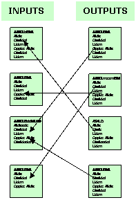
We have looked at the Design Process from the proposal document to the delivery of the design, and then at some Design Sequences (BREDIM and SADI) that encourage us to take a systematic approach to our designing. We have seen how simple questionnaires (PASE sheets, design checklists) and participatory planning processes (planning for real) give opportunity to users of locations – be they client or community – to contribute ideas for the elements and activities that the final design will incorporate. In looking at Sectoral and Zonal Analysis, we learnt about some principal design tools that gave us the ability to work out placement for design elements with regard to the natural energy flows through the site (sun, wind, rain, water and frost) and with regard to the efficient use of people’s own energies based on the frequency they need to visit the element (i.e. the distance it is placed from the centre of activity). These move us ever closer towards making the choices and taking the decisions that will optimise the success of our design. Here are some design methods that will help us further. You may notice that they embody many of the design principles. ANALYSIS OF ELEMENTSEarlier, we used the identification of inputs and outputs for three examples – chicken, horse and office – as a way into understanding the nature, use and production of resources, and we related them to our better understanding of how we can take our yields from systems in varied ways. Briefly, we noted any crossovers that existed between the three examples in terms of outputs becoming possible inputs. It is this identification of crossovers that turns that exercise into the basis for this design method of analysis of elements. Here, we are looking at the characteristics of all the potential elements in the design and then deducing a linking strategy or relative placement for them, based on the probable connections that can be made between them i.e. we want to put them in the right place. Note that characteristics is a bit wider than just inputs and outputs since it also refers to the intrinsic capability of the element to perform its main task (i.e. it wouldn’t matter what potential inputs and outputs there were if the element was incapable of succeeding in the location, such as a non-hardy plant in a cold climate, a machine with an inadequately low specification, or an untrained person).
So firstly, in our analysis of
elements, we should draw up listings of the needs (inputs)
and products and behaviour (outputs) of all
our elements. Do these on cards, with two cards per element (i.e. inputs
on one and outputs on the other). We can then line them · Of what use are the products of this element to the needs of other elements? · What needs of this element are supplied by other elements? · Where is this element incompatible with other elements? · Where does the element benefit other parts of the system? The answers will provide a plan of relative placement for our elements, or it may assist access of one element to the others. Take care to evaluate the intrinsics of the elements as an unsatisfactory appraisal will lead to either a rethink of the element or its elimination. Analysis of elements is a key design method. The attention to characteristics opens the door to the integration of elements, ensuring that we get their placement right and that we maximise beneficial relationships as we increase the functions that each element performs. It also aids us in increasing yield by introducing cyclical processes and it reduces the likelihood of wastes and thus pollutants. What is more, this design method is equally useful for existing locations where it can be used for fundamentally beneficial redesigns without necessarily the need for new elements. -topOBSERVATION
Observation is a principal method in site surveys, and is as much an ability to absorb the reality of a location as it is the simple use of our primary senses. It must be carried out at the location, unlike the preceding analysis of elements that can take place anywhere. We can approach the task of observation in a number of ways, each having the potential to reveal different information (see right). We can sit for a time and begin to notice patterns and processes and build up information in a site survey: how some trees prefer to grow in rocks, some in valleys, others in grasslands or clumps. We can observe waterflows on the site, where winds have bent branches or deformed the shape of trees, how the sun and shadows move, and where we find signs of animals resting, moving, or feeding. The site is full of information on every natural subject, and we must learn to read the landscape and its indicators. Be aware that information from one site visit tells us only the natural order in that season - if we can, we should make return visits over a year so that we see each season and its changes. The experiental approach leads us into using observation as a design method. After the initial site survey, you should take the opportunity to sit down in a location again and just look around. You are not necessarily looking for anything in particular, more for what the location returns to you during your period of observation (i.e. what it tells you). In urban areas, this often turns into people-watching, seeing the patterns of movement through a location, seeing where people stop to talk, where they sit and what parts they hurry through. You may then start to tie in features or conditions that are causal for this range of activity. Given the design brief, you can then begin to work out how you can build onto those features and conditions to achieve the outcomes required in the design. In a land-based design, you would be looking for feedback from the immediate topography/surface layout of the landscape, to see where elements may best be sited, such as a natural damp hollow for a water feature or a flattening out of the slope for the location of terrace beds. This is designing by expanding on direct observation of the site. -topRANDOM ASSEMBLIES
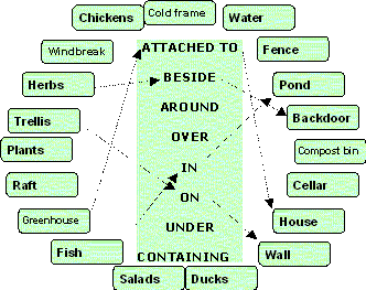
The process starts by having a set of placement or connective strategies. These are words like BESIDE, UNDER and ATTACHED TO. We set them out in a central column on a board. Then we make a series of cards that contain the elements in our design challenge and place them in a circle around the column of strategies (see figure). Pick an element card, place it next to a strategy, and then place successively other element cards against that same strategy until an interesting connection appears. The figure shows some obvious connections for the elements arranged around. Thus herbs BESIDES backdoor, and trellis ON wall. We can go further by linking connections and elements together i.e. plants ON trellis OVER pond CONTAINING fish. Is this useful? Well, plants on a trellis over a pond can create shade on the water surface and thus reduce fluctuations in water temperature, so benefiting the fish. The shade may also inhibit the growth of water surface plants, thus keeping the pond surface clearer for the fish to feed at. Finally, the plants on the trellis over the pond may provide security for the fish from marauding herons passing over. What might have seemed some unlikely combinations, turn out on analysis to provide some useful design outcomes. This design method works in reverse of analysis of elements – we work backwards from placement to function to benefits and system characteristics. We still achieve our goals, but in a creative and novel way. -topPLACEMENT IN THE LANDSCAPEThe placement strategies in random assemblies relate to design elements in micro and medium scale. We should also develop our ability for placement or relative location strategies in the larger landscape so that we make efficient uses of natural resources. The trick is to best use energy sources before they pass through and off your landscape, or disappear into it. Thus the strategy is to intercept those energies between their source and their sink, and to do it in a way that traps the highest potential of the energy and which makes it usable or storable. Hence creation of a series of swales (diversion ditches), dams and new interlinking routes on watercourses would ensure that water is stored upslope on a site and can thus be channelled by gravity for where it is most useful. The same thought should go into the effective placement of turbines to harvest wind energy and use it either to do mechanical work or to turn it into electricity. Shelterbelts and windbreaks need careful placing for maximum effect and solar energy should be harvested at every opportunity (see Sectors). FLOW DIAGRAMSThis is a design method for workplaces, from kitchen to factory. The preceding methods are not so important here as is the understanding of the flow through the process(es) involved in the work. The intention is to create an efficient workplace, as much as zonal analysis looks at creating an efficiently integrated location. Thus for a kitchen, it is worth mapping out a flow chart of typical activities and from these devise the best location for each element. You can mark out these locations on the ground, walk around and imagine you are preparing a meal. Are the knives and bowls stored close to the preparation area? Is the worktop stable enough for chopping and kneeding? Do you have to walk too far to the fridge? The technique of flow charts is about schedules or time-place movement. Thus it can also be used in designing traffic-ways, whether it is people flows through a location or transport carriers bringing in goods and loading and taking them away. -topOPTIONS AND DECISIONS
IDENTIFICATION OF LIMITING FACTORS
Constraints to design are typically thought of as limiting factors in the local landscape, such as lack of sunlight, steepness of slope, risk of flooding, and cold winds and frost pockets. But we would also recognise that limiting factors are not confined to this and can include financial, social, cultural or ethical considerations. Mark Fisher - Permaculture Design course handout notes www.self-willed-land.org.uk mark.fisher@self-willed-land.org.uk |
 This design method
is based on producing random associations between different
elements. It has the capacity to create what might seem to be senseless
connections between elements. However, sometimes these connections may
spark a new idea that can be pursued in the design. Thus
this process can free us from always using rational methods, and it
encourages us to consider unusual connections and look for their value.
This design method
is based on producing random associations between different
elements. It has the capacity to create what might seem to be senseless
connections between elements. However, sometimes these connections may
spark a new idea that can be pursued in the design. Thus
this process can free us from always using rational methods, and it
encourages us to consider unusual connections and look for their value. In a design
challenge, we have a starting point and some idea of where
we want to go – a desired goal. Between those two points, a
series of options open up which we need to test
by the opportunities available to us and by the
constraints we face (i.e. we may be rich in voluntary effort, but
poor in financial resources). A decision is made on which
options to take up and we make progress to our goal by
reaching the next stage of options. As we navigate through
the course between the two points, options open up or close down on
readily available evidence or as decision points are
reached. This design method is therefore ideally suited to working through
design challenges that have economic or legal
constraints where analytical or observational approaches are less helpful.
In a design
challenge, we have a starting point and some idea of where
we want to go – a desired goal. Between those two points, a
series of options open up which we need to test
by the opportunities available to us and by the
constraints we face (i.e. we may be rich in voluntary effort, but
poor in financial resources). A decision is made on which
options to take up and we make progress to our goal by
reaching the next stage of options. As we navigate through
the course between the two points, options open up or close down on
readily available evidence or as decision points are
reached. This design method is therefore ideally suited to working through
design challenges that have economic or legal
constraints where analytical or observational approaches are less helpful.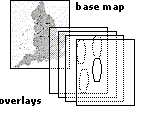 If you get stuck
sometimes in deciding the placement of an element, then a way to break out
is to decide where it shouldn’t go! This design method owes
its existence to Ian McHarg, a Scottish landscape architect and planner,
who spent most of his working life in N. America. When invited to assist a
community in protesting a proposed new road, he produced a base map
of the area and a series of transparent overlays. The
overlays mapped areas where there were good reasons why the
road should be excluded, such as too close to housing,
through a wildlife area or woodland, or where extra cost would be incurred
through needing bridges to be built. Once all the overlays were placed on
the base map,
If you get stuck
sometimes in deciding the placement of an element, then a way to break out
is to decide where it shouldn’t go! This design method owes
its existence to Ian McHarg, a Scottish landscape architect and planner,
who spent most of his working life in N. America. When invited to assist a
community in protesting a proposed new road, he produced a base map
of the area and a series of transparent overlays. The
overlays mapped areas where there were good reasons why the
road should be excluded, such as too close to housing,
through a wildlife area or woodland, or where extra cost would be incurred
through needing bridges to be built. Once all the overlays were placed on
the base map,