 |
||
|
The road protests against new bypasses over recent years have tended to polarise debate around issues that may not have immediate relevance to the communities affected by increasing road traffic. The constant antagonism generated should teach us that our systems for reaching decisions are unsatisfactory. Should the principles on which road protesters stand be allowed supremacy over local conditions? Pragmatism may suggest that the loss of some renewable woodland habitat is preferable to the pollution in urban areas from cars idling in traffic jams? What is the right answer? Can we be sure that local people are allowed to reach an informed decision which then strengthens the decision making process? Traditional methods of public participation at planning meetings often cause a confrontational atmosphere. This can discourage participation by the less vocal majority so that public meetings tend to be dominated by individuals who may have extreme views that do not necessarily represent the wider view of local people. Planning meetings usually take place in evenings at specific times that can reduce the numbers of people attending. The restricted time and also the location of public meetings may further reduce the possibility of widespread attendance. Difficult physical access can also cause problems for the disabled, the elderly and infirm as well as those who may have impairment of senses. The answer to these concerns is the development of creative participation methods that encourage the inclusion of all people in communities, and then to take those methods out into the community and in as many settings as possible, so making them accessible. Planning For Real (PFR) is the best known of these, but new ones are appearing by the day.
At the events, the model is laid out with cards placed around it. These show options (as many as 300 are available in the toolkit) which people put on the model to show what they want, and where they want it. There are also blank cards for people to write their own suggestions. Flags are also provided for people who may wish to Agree or Disagree with ideas already placed on the plan. Demographic information (gender, age range, rough home location) is also collected so that it can be judged later whether a good cross section of the community has been reached (total numbers reached are often in the 300-500 number). Following on from the open-air events, a public meeting is held at which all the options placed on the model are prioritized through group working into Now, Soon, or Later, with some indication of whether the community can carry out the improvement themselves or if they believe outside help is needed. This can then be developed into a full-scale Action Plan that lends immense support to community action, and is attractive and persuasive for funders. One of the advantages of PFR is that compromise and consensus become easier because the efforts of the participants become entirely focused on the physical plan/model. This allows practical non-threatening modes of interaction by the participants being anonymous i.e. the placing of an idea card on the plan/model versus standing up to speak at a public meeting. There is, however, one disadvantage – “Planning for Real"® is a trademark of The Neighbourhood Initiatives Foundation (NIF) a charity based in Telford. Like Permaculture, they safeguard the ethos and practice of PFR by requiring users to go on one of their courses, and for events using the term “Planning for Real” to be notified to NIF (The Poplars, Lightmoor, Telford, TF4 3QN, 0870 0770 0339, www.nifonline.org.uk).
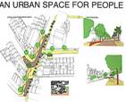
CREATIVE SPACES This is a toolkit
devised by the Architecture Foundation
to unleash the creative ideas of communities for local spaces that have
been neglected or forgotten, that are probably disliked and which
undermine the quality of a neighbourhood’s environment. The Foundation
recognises that community involvement in urban design must
start at the earliest stage, before any development plans have been drawn
up. Thus they believe that participatory urban design
offers the tools to talk about those spaces creatively and turn them
around for the benefit of the
community (we will look more at urban design later). But how do you get
started, and where do you get advice, support and information? The simple
answer is to have a look at their toolkit, which maps out a strategy of
preparing the ground, raising awareness and visualising the future.
It also provides a range of processes that include design
festivals, art projects and involving young people, and it illustrates
these with real, practical examples. The toolkit can be found on the
Internet (www.creativespaces.org.uk)
or in a 64-page book which is a condensed version that can be bought by
community groups for £5 from the Foundation (30 Bury St., London SW1Y 6AU,
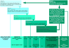
020 7839 9389). QUALITY OF LIFE CAPITAL This is a toolkit promoted by the Countryside Agency, English Heritage, English Nature and the Environment Agency. Its aim is to achieve the most gain in environmental, economic and social benefits from any land-use planning or management decision process. The approach requires standing back from areas or features and considering the benefits that they provide for human well-being (a matrix of "what matters and why?" – see figure). It then provides a systematic evaluation framework for all scales of decision-making that emphasises improvement of quality of life. A more complicated toolkit, it has proposed use in settlement planning, developing site briefs and plan policies, establishing a base line to inform decisions, and involving the public in decision making, and can be found only online so far (www.qualityoflifecapital.org.uk). Mark Fisher - Permaculture Design course handout notes www.self-willed-land.org.uk mark.fisher@self-willed-land.org.uk |